Saturday, December 29, 2007

Holiday Fun!

Second Lookout


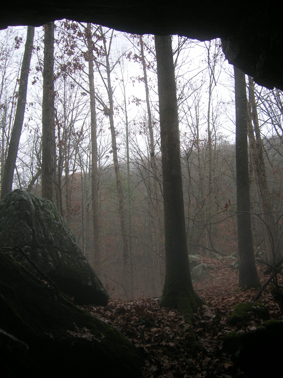
What a great couple of weeks we've had Exploring Izard County! Besides returning to Moonshine Cave, we also decided to take a stroll below the Second Lookout to explore the bluffline that runs along the ridge. We were rewarded with waterfalls, several little bluff-shelters, and an actual cave!
The cave is a small fissure that appears to go a good ways back into the mountain, but we don't know for sure because none of us had the energy (or guts) to proceed farther than a few feet inside the mouth. There was a fuzzy critter just inside, however...a hibernating bat which was completely oblivious to the mist gathered on its fur from the splashing drips of water seeping from the roof.

Needle's Eye and Moon Eye

Today, we were treeated to a hike that we have anticipated for some time...since friend of the site, Wayne Hill, e-mailed me about the feature known as "Needle's Eye and Moon Eye". After driving up Piney Creek...past the swimming hole lovingly known as "The Nars" (Narrows), we parked at the old Calvin Jones homeplace and proceeded to hike for about 30 minutes to a place above Mill Creek that delighted the whole crew!

The feature is a rock-formation in a bluff above the creek that features a tunnel through the bluff (Needle's Eye) , a large shelter that was once occupied by ancient peoples, and a wonderful natural bridge towering above (Moon Eye).

We all agree that his is one of the most astonishing sights we have visited and featured on the blog. Not only is the feature itself exciting, but the walk to the place was greatly enjoyed by the whole crew as well!

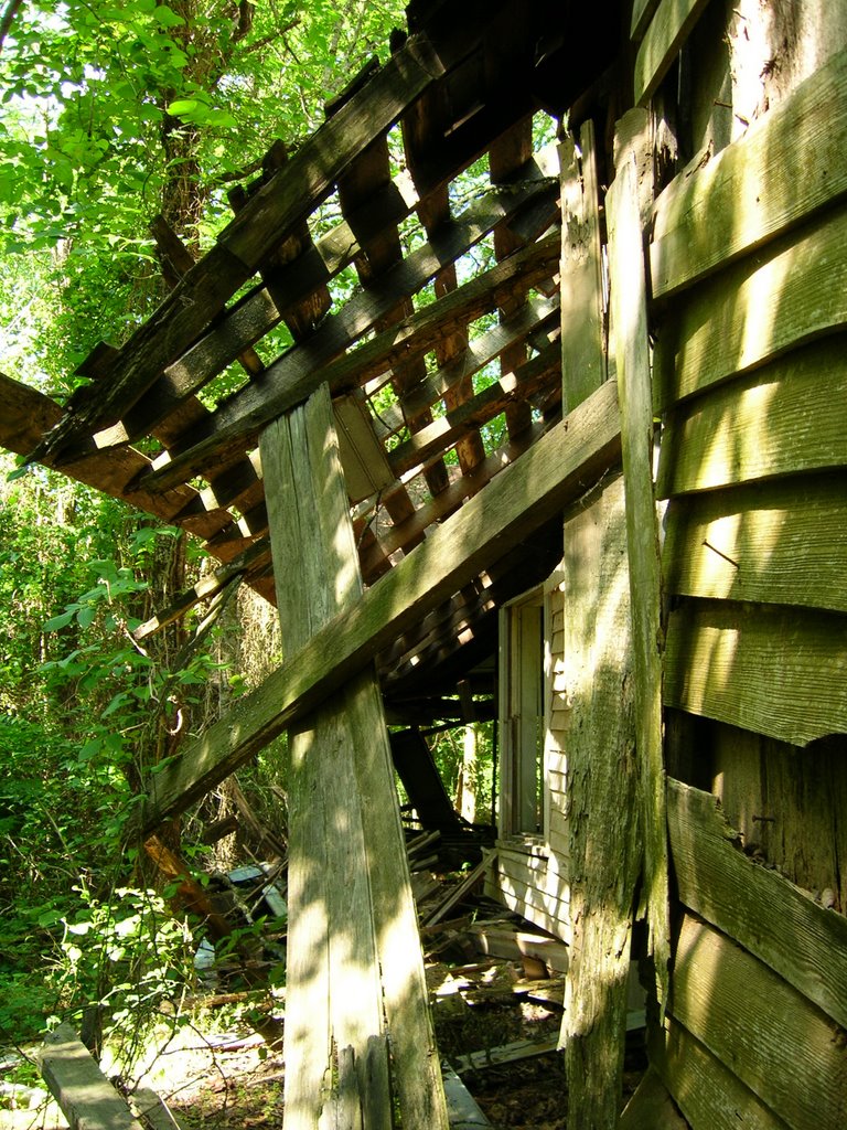
As an added treat, here's a couple of Photos of the old Doc Fleming/Hill place. It is rumored to be haunted! We've discussed adding a page to the EIC blogs called, "Haunted Izard County".


Sunday, December 2, 2007

Oxford/Wideman Road and Moonshine Cave

December 2, 2007
Moonshine Find


This afternoon decided a ride was in order because of the nice rain we experienced. The hills come alive during good rains and it's been a while since we've had one. With no particular place in mind, we set our course south along Sylamore Road and eventually decided to check the waterfall along Sylamore Road to see if it was flowing any more vigorously than the last time we went. Though still running somewhat, it wasn't gushing as we had hoped.

After poking around the bluffs in the hollow below the waterfall and shelter there, we decided to follow through on an idea at least one of us has voiced every time we've been to the site...we walked down the creek.

The creek-bed follows a winding but gradual course bordered on each bank by frequent bluffs and shallow shelters. About two hundred yards or so below the waterfall, my 7-year old son asked as we made our way carefully along the creek-bed, "Dad, would you be surprised if we found a cave while we are walking today?"

After a moment of thought, turning, I replied, "No, I wouldn't be surprised...I'd be happy though."

As I turned back to walk on ahead of our group, I looked across the creek to see a cave...pretty as you please...just above us.

No one had seen the cave...including my son...it was pretty weird! We climbed the bank of the creek to find the awesome cave veiled in mist rising after a light shower. The cave is of significant size...well-suited for habitation. Not a shelter, the cave looks to go some distance into the hill...we could not investigate because we had not anticipated a "find" like this and had not brought a single light.

Investigating the cave, we found it to have been well-dug by others in the search for ancient artifacts. The cave must be rich, because a few artifacts were lying on the floor in plain view...including a well-worn...hand-fitting hammer-stone. More modern signs included the bottom of a large glass jug and several metal barrel hoops. Though we have no way of knowing, our imaginations prompted us to dub the cave The Moonshine Cave until we can find any given name.


December 1, 2007

Oxford/Widem
an Road

The Newburgian and I got out early Saturday morning without a specific place to go in mind. We ultimately decided to drive the road between Oxford and Wideman in the northern part of the county. Along the way we were able to photograph two wonderful old churches/schoolhouses and a very interesting old house and barn. The old Schoolhouse (without steeple) is just outside of Oxford. The other church is in old Wideman. I'm not sure what the names of the old churches/schools are but will endeavor to find out. The old house is very interesting...rare in that it has a quarried-stone basement with windows. It appears to be very old and I intend to investigate its history.

Look for a post later in the week at Exploring Izard County with a few more of the photos we took...and possibly the names of the churches.

Tuesday, October 23, 2007

Group Outing to Natural Bridge near Dolph

We got word during the past week that our friend, Colt, was going to be in again for the weekend and wished to go see the Natural Bridge near Dolph. After friends and family joined the trek Sunday afternoon, we ended up with a group of 12.

We took the group, first, to the top of the arch and explained to them about the Natural Bridge's use in the past as an actual bridge. Those who owned the land long ago would each year pack dirt into the cracks and crevices across the top of the stone arch so that they could drive a wagon from field to field...a task that could take hours or days by going around the deep bluff-lined hollow of Calico Creek.

We then went down to see the arch in all its glory. The kids crawled through the tunnel in base of the bridge and happily jumped back and forth along the creek. Having experienced the beauty of the structure, we hiked downstream to the feature I had noticed the last time we visited the site...a cave. I did not get to climb the hill to investigate the place before and when we all did this time, we found a small domed-room with a round opening in its outside wall. It was amazingly similar to a Fred Flintstone-style house!

Yabba-Dabba-Doo!

We oohed and ahhed about the cave for a few minutes before hiking on "downstream" (in quotes because Calico Creek flows underground just below the cave)to investigate more of the hollow we had not yet seen.

Calico Creek Hollow (I'll call it that for lack of knowing any other name) is a stunning place. The clear, spring-fed creek runs through a channel cut deep into limestone rock with rock-bluffs rising high on both sides. Below where the creek flows under a cedar tree to disappear underground, the bottom upens up into a flat on the south side of the creek.

Just below this flat, the landowner's fence stretches across the dry creek-bed. That's as far as we got. We will return to investigate farther downstream to Goat Hollow and Cantrell Den when we get permission from the owner of the Goat Hollow portion of the creek.

This was our first outing of any size. It wasn't organized because of how it came together. We're hoping, however, to have more organized periodic outings in the future. We're hoping some of you would like to join us.

Friday, October 12, 2007

Colt's Labrynth (Mill Creek) 10/7/07

Over a year ago, Ryan told us he had a friend who owned some land with a shelter cave that had some sort of painting. Ever since, we've looked forward to getting to see the site and take a look. Sunday afternoon, we got to go.

After an interesting ride to the site, we climbed up the side of a steep ridge to the awesome fractured bluff-line near its top. Navigating our way carefully (and breathlessly (as you'll notice if you watch the videos at the YouTube Hunkahillbilly page [sidebar]) over boulders and along the base of the bluff, we made it to the shallow shelter that also hides a very small entrance to an extensive cave (later excursion, we hope).

My first impression of the bluff-painting that is applied on the underside of the overhanging rock was that it did not look very old. Upon further inspection, however, it became clear that there was much of the painting that is faded. The visible portions are clearly not any form of modern pigment but looks to be a natural paint of some sort. It's quite interesting and deserves a closer look. As far Colt the landowner knows, it has never been studied.

After admiring the amazing painted sandstone bluff towering above the shelter, we paused to take a photo of our little troop. We then proceeded to enter a fissure in the bluff formed by a gigantic triangular portion that had separated from the bluff sometime in the distant past. The small gorge formed by the fissure is about thirty feet long and is walled on each side by a shear 30ft-40ft face. Rather than retracing our way back out, we crawled through a narrow fissure that led to the front of the broken off triangle of rock. It was a tough climb and a tight squeeze!

After admiring ourselves for having been able to get out through the narrow fissure (really we just needed to catch our breath!), we explored other passages similar as we made our way to the top of the bluff to see the amazing view of Mill Creek and the surrounding hills.

WE are so thankful for landowners like Colt, who are eager to share the unique and wonderful places they possess! Thanks, Colt, for the great adventure.

Sunday, September 30, 2007

Cave and Spring near Old Sand Mine at Nasco

At the area's district fair Friday night, I ran into the owner of the Old Sand Mine property on the River at Nasco. While talking with him, he told me about a cave near the old mine and gave me directions. Because he is in the process of selling the property, he suggested we make our visit as soon as possible.

We did so. We made plans late last night and got up with the sun to drive down the old Nasco Traverse to do a bit of real exploring.

It was an amazing morning. A spring below the cave empties into Lyons creek several hundred feet below. We crossed Lyons Creek after finding a suitable place to park our vehicle and found the spring branch the gracious landowner had described. Ascending a natural staircase carpeted in a rich emerald green moss, we made our way up the steep branch that is a series of tiny trickling waterfalls. Crystal pools of Ozark spring-water reflected the lush canopy of vegetation creating astounding contrasts with the vibrant moss that covers each rock along the stream.

Making our way breathlessly over boulders up the final steep climb, we finally made our way to a bluff which revealed a cave opening.

A stream of water flows from the mouth of the cave to disappear into the loose gravel that makes up the floor. It only took a glance to see that any attempt at exploring the cave beyond a few feet would prove a wet and painful experience. Though we had brought lights, we had not brought kneepads or any way to keep equipment dry. To explore into the cave (which looks enticing...you can glimpse deep passages from the water's edge), would have required more determination than we had at the time. Hopefully we will get to return more prepared.

Running parallel to the spring-branch is a wash...though currently dry, it must have plenty of water throughout the year because the moss on bluff-shelves that create a picturesque "grand staircase" up the little hollow to an interesting bluffface some twenty-to fifty feet higher up the hill than the cave described.

The trip[ today was wonderful. We love visiting new places we've never seen. And this was one p[lace really worth seeing!

I would like to return in the winter if we can get permission. From the position of the cave's mouth, I'm almost sure one would have an excellent view of the White River from that position.

Sunday, September 23, 2007

Quick Trip To Calico Rock

Very early this morning, Jaca, an integral member of our crew and at the top of my wife's list of usual suspects, stopped by and said, "Let's go for a ride!" As I do most days he does this, I complied.

We headed north and west to Calico Rock and captured images of one of the old schoolhouses in Calico Rock. Though I don't know much of the history of this building as of yet, I intened to find out when it was built and when it also operated.

It's an awesome old structure...standing high an proud, though looking rather worn...and terribly neglected. Walking around the stately old hulk, I was both invigorated by the majesty of the place and saddened by it's state.

It's not the first time I've felt these same old feelings. Several times since we started EIC, I've experienced them. The first was the old hotel/boarding-house along the tracks at Mount Olive. Others...like the old schoolhouse in the old Strawberry Township...come to mind as well. I am also reminded of the many wonderful old buildings that so captivated me as a child that have either burned or just rotted and collapsed.


Friday, September 14, 2007

September 8, 2007

Totally Gid, Dude!

Today, we took our friend, Donny, to visit the amazing features at Gid. We visited both waterfalls and the old Indian Shelter above the Grist-Mill.

It was a beautiful day, though humid. The stream of water falling off the rock at the smaller of the two falls (upstream) was quite thin. We took the opportunity to spend a little time wandering around and looking at some of the interesting formations a little farther down the creek. We are quite sure the creek bottom and the hollow it follows would make an excellent hiking trail.

Downstream, at the Grist-Mill Waterfall, we drove to the top of the falls and got some footage and shots of the feature from above. Afterwards we descended the hill and enjoyed the cool spray as the spring-fed water pummeled the rock at the foot of the falls.

As we headed out, we stopped at the top of the opposite ridge and visited the old Indian Cave there. More great video! This feature is truly worth notice...a large shelter with two skylights...one of which has a stream of water falling into.


September 11, 2007

Return to Lafferty Cave

Rick and I both have sons whose birthdays occured this week. Today, we took one of them...Rick's...also a member of the EIC crew...to Lafferty. We climbed the falls up to the cave and went in to take a look. A hundred feet or so into the cave lies a pair of streams. Following the second of these brought us to a flooded tunnel. Though we had three lights, we had not come prepared to wade an underground creek. One day we will return fully prepared for an excursion.

We had fun, though. As we always do.

Denny

Monday, September 3, 2007

Lafferty Springs

On Saturday, the first of September, our crew took a drive to Lafferty in order to document the spring and the cave above it. We arrived at approximately 10;45 a.m. and spent about 45 minutes at the location. While there, we explored the various outlets along the side of the hill, some which have been tapped for use by homes down in the Lafferty Valley below the springs.

We also ascended the steep wash that stretches from the cave at the top to the branch at the bottom. Because we did not bring any lighting, we only took a peek inside the cave and decided to come back for a more thorough investigation of the feature at a later date.

Our short trip allowed us to get some great shots of the Sanctuary Ranch as well as some of the dam on Lafferty Creek.

A reader had commented about the stone basin located at the spring in an earlier post ...which we photographed and have posted at EIC.

The spring was not as robust as we have seen in the past. An extended period of dry weather is to blame. We plan to return when we can capture the spring as it cascades down the wash.